|

|
| estuary |
thamesestu |
thamesestu |
Plant- and Animal Kingdom |
estuary |
Weather |
thamesestu |
thamesestu |
Geography |
thamesestu |
thamesestu |
thamesestu |
thamesestuary |
| |
 An endlessly varying fleet of craft has traded to every corner of this area since before Roman times. Every town and hamlet had its`own quay, dock, hythe or jetty. Farms in the area soared in value if they had access to salt water. All manner of craft have used these trade routes, but Thames spritsail barges evolved as the queens of them all and some thirty or forty of them have been preserved. Thus you can still occasionally see a lofty mast way inland behind the sea wall. Find the old dock or jetty and look for a green overgrown lane leading to the local farm buildings. Some have fallen to the bulldozer but many remain. Most are pretty decrepit now but one at least remains as solid as ever for it was built in 1832 from stones from old London bridge. This is Beamont Quay in the heart of the Secret Water of dream breeders, Swallows and Amazons. An endlessly varying fleet of craft has traded to every corner of this area since before Roman times. Every town and hamlet had its`own quay, dock, hythe or jetty. Farms in the area soared in value if they had access to salt water. All manner of craft have used these trade routes, but Thames spritsail barges evolved as the queens of them all and some thirty or forty of them have been preserved. Thus you can still occasionally see a lofty mast way inland behind the sea wall. Find the old dock or jetty and look for a green overgrown lane leading to the local farm buildings. Some have fallen to the bulldozer but many remain. Most are pretty decrepit now but one at least remains as solid as ever for it was built in 1832 from stones from old London bridge. This is Beamont Quay in the heart of the Secret Water of dream breeders, Swallows and Amazons.
|
|
|
|
|
| |
An estuary is a partly enclosed coastal body of water with one or more rivers or streams flowing into it, and with a free connection to the open sea.
Estuaries form a transition zone between river environments and ocean environments and are subject to both marine influences, such as tides, waves, and the influx of saline water; and riverine influences, such as flows of fresh water and sediment. The inflow of both seawater and freshwater provide high levels of nutrients in both the water column and sediment, making estuaries among the most productive natural habitats in the world.
Most modern-day estuaries were formed during the Holocene epoch by the flooding of river-eroded or glacially-scoured valleys when sea level began to rise about 10,000-12,000 years ago.
Estuaries are amongst the most heavily populated areas throughout the world. As a result, estuaries are suffering degradation by many factors, including sedimentation from soil erosion from deforestation; overgrazing and other poor farming practices; overfishing; drainage and filling of wetlands; pollutants including heavy metals, PCBs, radionuclides and hydrocarbons from sewage inputs; and diking or damming for flood control or water diversion.
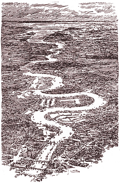
The Thames Estuary is the estuary in which the River Thames meets the waters of the North Sea.
It is not easy to define the limits of the estuary, although physically the head of Sea Reach, near Canvey Island on the Essex shore is probably the western boundary. The eastern boundary, as suggested in a Hydrological Survey of 1882-9, is a line drawn from North Foreland in Kent via the Kentish Knock lighthouse to Harwich in Essex. It is to here that the typical estuarine sandbanks extend. The estuary has the world's second largest tidal movement, where the water can rise by 4 metres moving at a speed of 8 miles per hour.
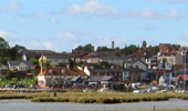
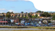
The appellation Greater Thames Estuar applies to the coast and the low-lying lands bordering the estuary itself. These are characterised by the presence of salt marshes, mudflats and open beaches: in particular the North Kent Marshes and the Essex Marshes. Rising sea levels in places may make it necessary to flood some of that land to take the pressure off the defences. Man-made embankments are backed by reclaimed wetland grazing areas; there are many smaller estuaries, including the Rivers Colne, Blackwater and Crouch; and there are small villages concerned with a coastal economy (fishing, boat-building, and yachting). The Isle of Sheppey, Foulness Island and Mersea Island are part of the coastline.
Where higher land reaches the coast there are some larger settlements, such as Clacton-on-Sea (to the north in Essex), Herne Bay in Kent, and the Southend-on-Sea area within the narrower part of the estuary
The Thames Estuary is part of Thames Gateway, designated as one of the principal development areas in Southern England. Description above is from the Wikipedia articles Estuary and Thames Estuary, licensed under CC-BY-SA, full list of contributors here. |
|
| |
„The estuaries of rivers appeal strongly to an adventurous imagination. This appeal is not always a charm, for there are estuaries of a particularly dispiriting ugliness: lowlands, mudflats, or perhaps barren sandhills without beauty of form or amenity of aspect, covered with a shabby and scanty vegetation conveying the impression of poverty and uselessness. Sometimes such an ugliness is merely a repulsive mark. A river whose estuary resembles a breach in a sand rampart may flow through a most fertile country. But all the estuaries of great rivers have their fascination, the attractiveness of an open portal. Water is friendly to man. (…)
The commander of the first Roman galley must have looked with an intense absorption upon the estuary of the Thames as he turned the beaked prow of his ship to the westward under the brow of the North Foreland. The estuary of the Thames is not beautiful; it has no noble features, no romantic grandeur of aspect, no smiling geniality; but it is wide open, spacious, inviting, hospitable at the first glance, with a strange air of mysteriousness which lingers about it to this very day. (…)
Amongst the great commercial streams of these islands, the Thames is the only one I think open to romantic feeling, from the fact that the sight of human labour and the sounds of human industry do not come down its shores to the very sea, destroying the suggestion of mysterious vastness caused by the configuration of the shore. The broad inlet of the shallow North Sea passes gradually into the contracted shape of the river; but for a long time the feeling of the open water remains with the ship steering to the westward through one of the lighted and buoyed passageways of the Thames, such as Queen's Channel, Prince's Channel, Four-Fathom Channel; or else coming down the Swin from the north. The rush of the yellow flood-tide hurries her up as if into the unknown between the two fading lines of the coast. There are no features to this land, no conspicuous, far-famed landmarks for the eye; there is nothing so far down to tell you of the greatest agglomeration of mankind on earth dwelling no more than five-and-twenty miles away, where the sun sets in a blaze of colour flaming on a gold background, and the dark, low shores trend towards each other.“
[Joseph Conrad, „The Mirror of the Sea“, 1905] |
|
The hydrological definition of an estuary: "An estuary is a partly enclosed body of water in which which river water is mixed with seawater and so is defined by salinity rather than geography."
The Admirality Pilot in the 1970s defines the Thames Esturay as: "actually streching from the Naze (Walton-on) to the North Foreland" |
|
> top
|
| estuary |
thamesestu |
thamesestu |
thamesestu |
thamesestu |
thamesestu |
thamesestu |
thamesestu |
thamesestu |
thamesestu |
estuary |
thamesestu |
thamesestu |
thamesestu |
thamesestu |
thamesestu |
thamesestu |
thamesestu |
thamesestu |
thamesestu |
thamesestuary |
| |
|
|
|
|
| |
|
|
|
| |
|
|
|
|
If you want to be in the know about your user statistic and those of the other users of this site, click on this link to the webanalysis, log in under the user name "I_m" and the password "informed" and you'll be surprised.
top | home | logbook | photos | sources | maps | links
© Jan Holthusen 2012 | Webmaster
|